
Fayette County and surrounding areas will be under a Winter Storm Watch beginning at 9 p.m. Wednesday through 7 a.m. Friday.
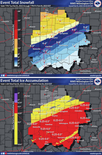
A heavy mix of precipitation is possible. Total snow accumulations of 2 to 4 inches and ice accumulations of one quarter to one half of an inch are possible.
Power outages and tree damage are likely due to the ice. Travel could be nearly impossible, according to the Fayette County Sheriff’s Office. The hazardous conditions could impact the morning or evening commutes Thursday and the morning commute Friday.
The forecast as of Tuesday afternoon by the National Weather Service office in Wilmington calls for:
Wednesday
Rain, mainly after 11 a.m. High near 44. South wind 8 to 10 mph. Chance of precipitation is 100%. New precipitation amounts between a half and three quarters of an inch possible.
Wed. night
Rain before 2 a.m., then rain and sleet. Low around 26. South wind 5 to 10 mph becoming north after midnight. Chance of precipitation is 100%. Little or no sleet accumulation expected.
Thursday
Rain before 2 a.m. Thursday, then rain and sleet. Low around 30. Southeast wind 6 to 10 mph becoming northeast after midnight. Chance of precipitation is 100%. Little or no sleet accumulation expected.
Thursday night
Snow and sleet, becoming all snow after 10 p.m. Low around 16. Chance of precipitation is 100%. New snow and sleet accumulation of 1 to 3 inches possible.
Friday
Mostly cloudy, with a high near 21.
Friday night
Partly cloudy, with a low around 0.
Saturday
Sunny, with a high near 22.
Saturday night
Mostly clear, with a low around 9.
Sunday
Mostly sunny, with a high near 33.
Sunday night
Mostly cloudy, with a low around 16.
Monday
Partly sunny, with a high near 30.